Construction Progress Mapping and Site Surveying. London-based Aerial Photography and Drone Surveys
Get Started
Watch our short video to explore examples of our work and discover how our Drone Construction Services can benefit you.
Click on an image below to find out more!
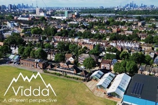
Aerial construction site photography and filming. Showcase your site at every stage of development!
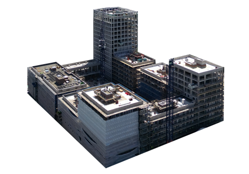
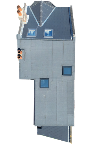
Assess the Inaccessible. Find out more about our wide range of aerial surveying services!
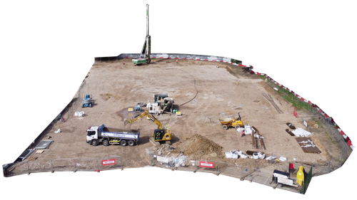
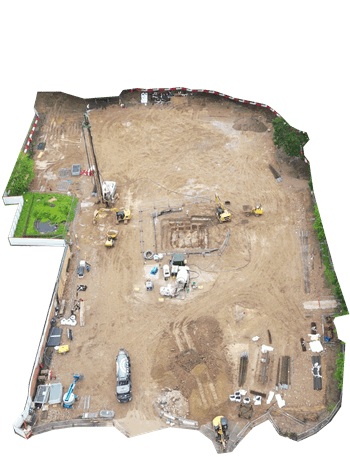
Document each stage of construction site progress with drone photography or aerial filming.
Filming and photographing at all angles of the site to give a comprehensive view of your construction site.
Document the state of the site at any stage
Progress photography can:
Showcase your final product
Aerial imaging can:
Amplify your media
Our editing capabilities include:
Our client aimed to enhance their marketing efforts by clearly showcasing the loft conversion process to their customers. Vidda undertook four site visits to capture the progress at each stage, filming every detail. We then meticulously edited this footage into a compelling advertising video, providing customers with a clear and engaging visual journey of what they can expect from start to finish.
"Vidda took fantastic before, during and after footage to advertise our loft conversion work. Their final edited film has really allowed customers to appreciate our work and makes us stand out from our competitors when quoting for work."
Tom, LG Lofts
Assess the inaccessible with drone surveys. Discover how drone surveys can make you operations more efficient.
Some benefits of drone surveying include:
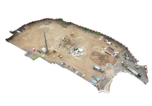
Combining georeferenced drone photos into:
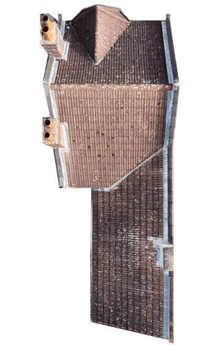
Thermal drone images to assist with:
Processing and reporting the data
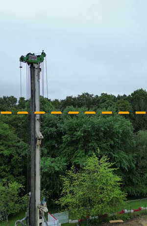
Our client, a large government strategic construction supplier, wanted to minimise the height of a tower crane to hopefully prevent the extra costs of having to report a Notice To AirMen (NOTAM), however the crane could possibly collide with the trees in the site vicinity. As terrestrial surveying techniques failed to identify the height of each tree, Vidda was insructed to perform a tree survey to identify the minimum height of the crane to avoid collision with trees throughout the project.
After obtaining the necessary data, permissions and plans, Vidda performed a survey to obtain georeferenced images throughout the site and above the tree line. These were then analysed to suggest the current tree line height, after accounting for potential tree growth throughout the project, the minimum crane height recommendations were then presented to the client in a detailed report.
We aim to make your experience as seamless and convenient as possible. To begin the process, simply fill out our Quote form using the link below. We understand that every project is unique, and we are more than happy to accommodate bespoke requests. Note that flying is weather dependent, so if possible, please provide a timeframe of when you need the job completed.
Once we receive your booking, our detailed preparation process begins. We conduct a thorough planning phase, including a "virtual survey" using satellite imaging and street view to assess the area and identify any potential obstacles or limitations. We also check the regulations in your area to obtain necessary approvals and get back to you with a quote.
With a flight plan created, we strategically choose the optimal day with favorable weather conditions and let you know when we'll be filming. Our skilled and experienced pilots take care of the filming according to your requirements, capturing the desired imagery with precision. The best part? You don't need to be on-site during the flight.
After the survey, our dedicated team securely handles the captured images and processes them according to your specific requirements. Whether it's photos, videos or surveys, we ensure that the final results meet your expectations. We transfer the processed files via secure online file transfer methods, ensuring the confidentiality and integrity of your data.
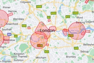
We serve London and its surrounding areas for smaller projects, and we cover the entire UK for larger projects.
Yes, we can operate in flight-restricted areas, though this requires an additional fee and application time. Check the London drone restrictions on our blog for more information.
Absolutely! Contact us for an example.
Our drone pilots are fully licensed by the Civil Aviation Authority (CAA) with the A2CoC as a minimum and have extensive experience in various types of aerial operations.
We are members of DroneSafe and attend industry events and conferences likeDroneX.
Our pricing is based on a quote system, depending on the size and complexity of the site. Prices start at £150 for drone filming at a residential project, for a larger construction site you can expect to pay around £200 per site visit. For post processing work like video editing or survey analysis we charge £50 per hour. Prices include VAT as we are not VAT registered.
Yes, we offer discounts for repeat customers and long-term projects. Please contact us for more details.
We accept online card payments and bank transfers.
No, in most cases, your presence on-site is not required. However, we may require a site safety induction if the permitted take off area is on an active site.
Typically, it takes about 5 business days to process and deliver the final product, depending on the complexity of the project.
We use secure, encrypted online folders to share data and ensure that only authorised individuals have access.
Our construction filming services encompass 360-degree orbital flights around the site, aerial flyovers, and downward-looking flights for comprehensive coverage. We also offer machinery filming and can coordinate with major operations such as crane assembly to capture crucial moments.
For the best results, we recommend progress photography every 3-6 weeks, depending on the project's size. However, capturing key milestones before and after significant phases is most crucial. We can also adjust the schedule to fit your budget.
Standard editing includes compiling and transitioning the footage into a video of your desired length and adding company logos and text. We can also overlay plans or projected images onto the video.
We offer thermal and photogrammetry services including topographical mapping, 3D modelling, volumetric surveys, inspections, monitoring, heat loss mapping, roof inspections and moisture detection.
At Vidda, safety is paramount. We adhere rigorously to high safety standards, drawing from extensive offshore experience where safety demands are exceptionally high. In addition to participating in client safety systems, we conduct our own thorough risk assessments and provide appropriate personal protective equipment (PPE) to ensure the well-being of our team and those around us.
We provide standard public liability insurance of £1 million, which can be increased to £5 million if needed. Additionally, we can offer £50,000 in professional indemnity insurance. Please contact us for specific insurance requirements for your project.
We work with construction businesses of all sizes, from local builders to large companies that are government strategic suppliers.
Yes, we can schedule regular flights to document progress and provide you with updated images and videos as per your requirements.
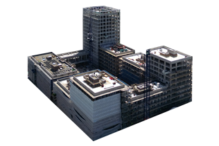
Yes, we offer 3D modeling services using photogrammetry to help with planning and visualisation of construction sites.
Click on a blog article below to read tips for successful aerial imaging and about our recent work.
Got a question? Send us a message using the details below and we will get back to you as soon as possible. Don't forget to follow @ViddaDrones on social media to see what we're up to.